
Flood Forecasting System
Team
Project Owner
Dr. Upul Jayasinghe, upuljm@eng.pdn.ac.lk
Scrum Master
Imesh Udara Ekanayake, imeshuek@eng.pdn.ac.lk
Team members
E/17/006, ALAHAKOON A.M.H.H, e17006@eng.pdn.ac.lk
E/17/176, KUMARA W.M.E.S.K, e17176@eng.pdn.ac.lk
E/17/338, SRIMAL R.M.L.C, e17338@eng.pdn.ac.lk
Table of Contents
Introduction
    Floods are the most destructive form of natural hazards in both local and global context.
    This is true in terms of both loss of life and property damage. Early flood forecasting can
    be used to identify potential areas of flooding in order to develop mitigatory planning and
    evacuation programs to remove people from such areas during flooding
    and also to implement suitable preventive measures to avoid damage to properties.

    In this project, our main objective is to build a flood forecasting system for Mi Oya river
    basin(Sri Lanka).Mi Oya Basin is heavily affected by seasonal flooding and droughts.
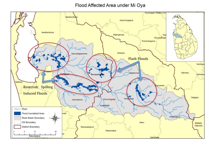
    As per the available data, floods in the Mi Oya basin are unleashed due to river overflow
    and reservoir spilling. Out of the several reservoirs located in the basin, Tabbowa and
    Inginimitiya are crucial in worsening the flood impacts as these two reservoirs are
    frequently spilling under adverse weather conditions. As such, the prevalence of a
    real-time flood forecasting model with the incorporation of the reservoir operations
    for the entire basin is essential to alleviate the flood induced impacts while
    preserving the optimum volume of water in the major reservoirs in the basin.
Solution
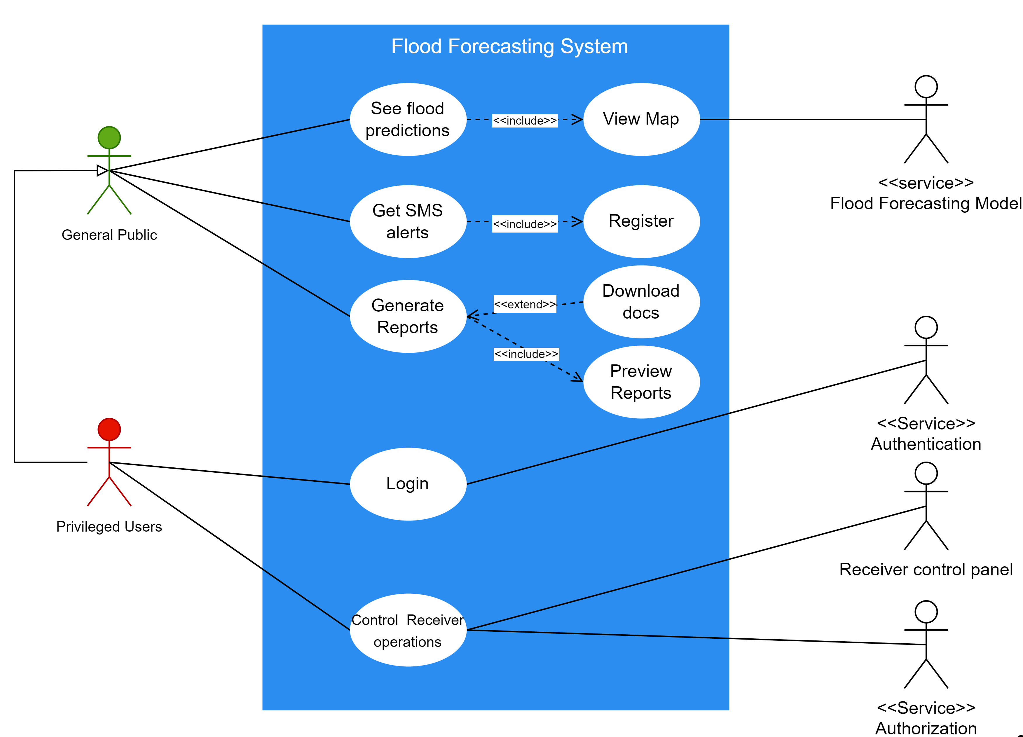
The proposed solution is to implement a simple data-driven or machine learning model to
identify a direct mapping between the inputs(e.g., precipitation(P), temperature(T),
potential evapotranspiration(PET), etc.) and outputs(In-flow level) without detailed
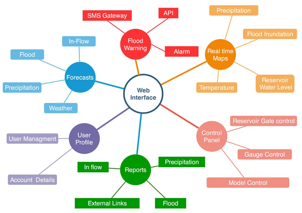
consideration of the internal structure of the physical process. Also the system is
consist of a web interface. The interface consists of three major modules as community
view,control panel, and report. The warning messages are displayed with a map depicting
the inundation extent in the community view, which is the interface for the public. Further,
the community members are allowed to register their mobile numbers to receive warnings
as SMS when such warnings are broadcasting at the disaster management center. A summary
of past floods can be generated from the Report module for a required time period. Control
panel provides access to the simulation module, gate operation module, flood warning
dissemination module, access control module, etc. Only privileged users have access to the
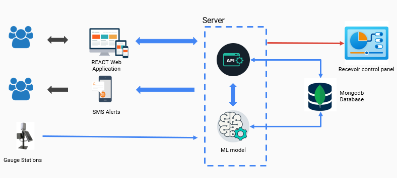
control panel. The figure below outlines the highlevel structure of the web application.
Solution Architecture
Requirement Analysis
| Functional Requirements | Nonfunctional Requirements |
|---|---|
| Forecast Floods and show critical regions in maps | Reliability |
| Warn general public by SMS alerts | Scalability |
| Generate flood reports | User experience |
| Control reservoir operations | Security |
Usercase Diagram
Highlevel System Overview
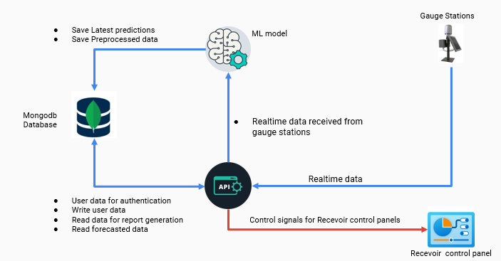
Data and Control Flow
Web Application Overview
Links
Department of Computer Engineering